 Welcome to UAVFLY – Commercial, Industrial and Domestic Drone Photography
The very latest technology in drone photography.


✓ We will cover large sites, rapidly
✓ Reduce surveying costs
✓ Access difficult sites
✓ Provide accurate high-resolution imagery
✓ Reduction in H&S incidents
Benefits of Using Uavfly Surveys
We use the very latest technology to enable you to work smarter. Aerial drone footage is only one small element of our service, when aligned with 3D
interactive scans, uavfly are able to give you a complete overview of any building, work site or estate.
Get real-time data enabling smarter work decisions to be made. We keep everything fully compliant with the rapidly changing laws around UAV flight in the UK. All our pilots are Civil Aviation Authority registered and regulated, Insured, and fully qualified to GVC standards, and will obtain all relevant permissions before undertaking any flights. We use pre-planned flight paths and up to 300X Zoom cameras for detailed imagery that helps you to work smarter and much more efficiently.

Our Equipment
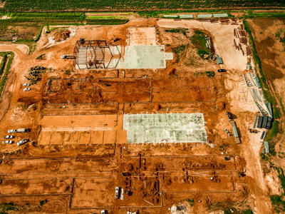
Construction Drone Surveys
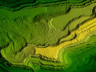
Uavfly Drone Site Surveys use the latest technology to offer construction professionals alternative visual options, enabling you to work smarter. Drones offer safer alternatives to external work and working at height. We have a drone for every task, whether you require highly accurate digital measurements, thermal investigations and thermography, site progress monitoring or just high quality imagery, we can deliver.
Using the latest Pix4d photogrammetry software aligned with our own dedicated RTK base stations, enables us to acquire huge amounts of accurate data to be extrapolated out of the images taken.
UAVFLY Thermal Drone Surveys
Uavfly are specialist thermal survey contractors. We have coupled the very latest in thermal technology cameras, to the safest drones around, combined with a national pilot network to give unparalleled service to our customer base. Our service includes data collection, post processing, and AI analysis to produce 98% accurate reports on your solar assets.